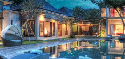
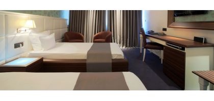
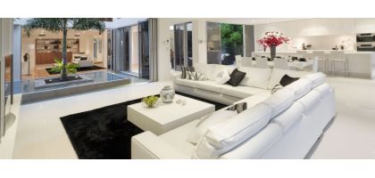
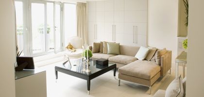
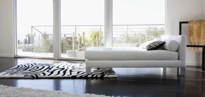
Sea View (T1)
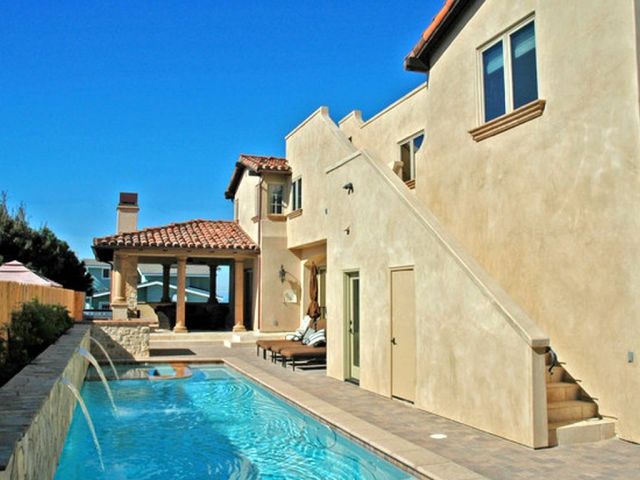
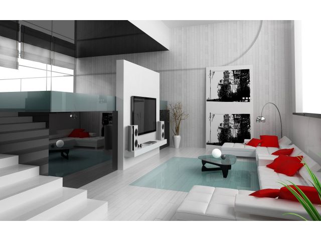
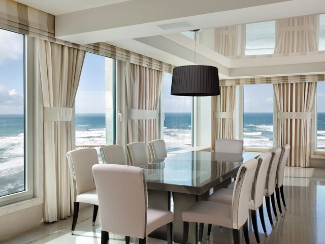

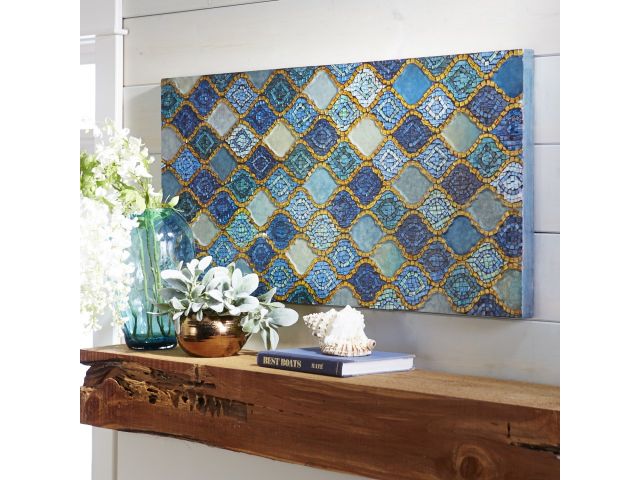
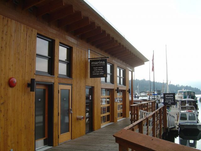
Apartment @ Colares - Sintra (Lisboa) 77m2 € 501/day
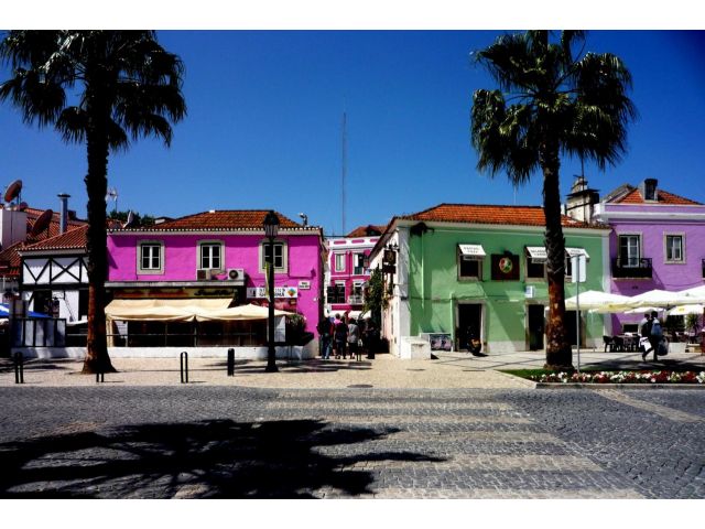
This property combines the tranquility of the mountain with the freshness of the sea. Sintra is one of the 10 romantic cities of the World with high historical and cultural interest. With fast and comfortable accesses, in an instant you will travel to Lisbon, the capital of Portugal. 4 rooms in 77 m2 make this T1 a pearl of relax and relaxation. Ideal for a couple, in a short holiday / weekend.
Colares is a civil parish along the coast of the municipality of Sintra. The population in 2011 was 7,628,[1] in an area of 33.37 square kilometres (12.88 sq mi).[2]
Contents
[hide]History

Even before there was a "Portugal", the region of Colares was a place of human movement and settlement. By the Roman occupation of the Iberian peninsula, the architecture of Colares was carved by Latin inscriptions, such as one found near the mouth of the Maçãs River: SOLI ET LUNAE CESTIVIUS ACIDIVIS PERENNIS LEG. AVG. PR. PR. PROVINCIAE LUSITANAE.
It was conquered and held by Sigurd I of Norway for a few months in 1108 in the Norwegian Crusade.
After a period of Moorish occupation, forces loyal to Afonso Henriques conquered the region, as a sequence of their victory in Sintra, around 1147 The region remained in the hands of the Crown until 1385, when it was donated by John I to the constable Nuno Álvares Pereira to compensate the mercenary for his support against Castile.
These lands returned to the crown following the death of Infanta Beatriz, mother of Manuel I.
The historical village of Colares, which was important in the nation's pre-history, obtained a foral early after its creation. The parish of Nossa Senhora da Assunção was a bishopric rectory in the old comarca of Torres Vedras, and Colares was the seat of its own municipality, attributed to King Afonso III, in May 1255. A new foral was issued on 10 November 1516 by Manuel I.
In 1801, the municipality of Colares included 1930 inhabitants, and by 1849, it already had 3341 inhabitants.
During administrative reforms, on 24 October 1855, the municipality of Colares was extinguished and the territory integrated into the municipality of Sintra, as a civil parish.
Geography

_-_Mar_2010.jpg)
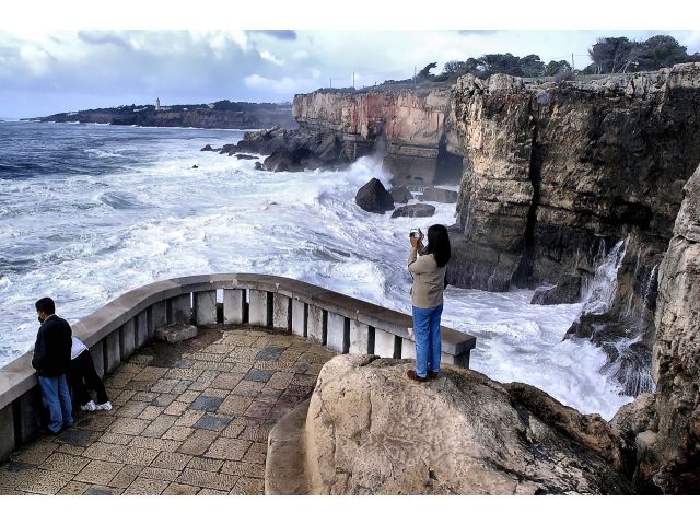
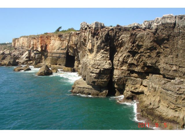
The civil parish is located on the western coast of Portugal, and marked by Europe's extreme western extent: Cabo da Roca. Its contains the settlements Almoçageme, Atalaia, Azenhas do Mar, Azóia, Colares, Eugaria, Gigarós, Mucifal, Penedo, Praia das Maçãs and Ulgueira.
Architecture
Prehistoric
- Dolmen of Adrenunes (Portuguese: Anta de Adrenunes)
- Prehistoric Monument of Praia das Maçãs
Archaeological
- Archaeological Site of Alto da Vigia (Portuguese: Sítio Arqueológico do Alto da Vigia)
- Roman villa of Santo André de Almoçageme (Portuguese: Vila Romana de Santo André de Almoçageme)
- Tholos tomb of Bela Vista (Portuguese: Tholos da Bela Vista)
- Tholos tomb of Monge (Portuguese: Tholos do Monge)
Civic
- Building of Correios, Telégrafos e Telefones (CTT) de Colares
- Cinema/Theatre Gomes da Silva (Portuguese: Cine-Teatre Gomes da Silva)
- Cellar of the Viscount Salreu (Portuguese: Adega do Visconde Salreu)
- Estate of Quinta do Casas Novas
- Estate of Quinta da Fonte
- Estate of Quinta da Fonte Velha
- Estate of Quinta de Vale Marinha
- Estate of Quinta do Pé da Serra
- Estate of Quinta do Rio Milho
- Estate of Quinta dos Freixes
- Estate of Quinta Mazziotti/Quinta do França
- Estate of Quinta Milides
- Estate of Nossa Senhora de Melides
- Fountain of Espoujeiro (Portuguese: Chafariz do Espoujeiro)
- Lighthouse of Cabo da Roca (Portuguese: Farol do Cabo da Roca)
- Pillory of Colares (Portuguese: Pelourinho de Colares)
- Primary School of Azenhas do Mar (Portuguese: Escola Primária das Azenhas do Mar)
- Residence of Quinta da Bela Vista (Portuguese: Casa da Quinta da Bela Vista)
- Residence of Quinta do Cosme (Portuguese: Casa dos Lafetás/Quinta do Cosme)
- Residence of Quinta do Vinagre (Portuguese: Casa da Quinta do Vinagre)
- Residence (Pombaline) on Largo do Pelourinho (Portuguese: Casa Pombalino no Largo do Pelourinho)
- Residence (17th century) on Largo do Pelourinho (Portuguese: Casa Setecentista no Largo do Pelourinho)
- Residence on Avenida do Atlântico, 180 (Portuguese: Moradia na Avenida do Atlântico, 180)
- Residence on Rua da Abreja (Portuguese: Casa na Rua da Abreja)
- Residence on Rua da República (Portuguese: Casa na Rua da República)
- Residence Saloia (Portuguese: Casa Saloia no Penedo)
- Summer cottage of Praia das Maçãs (Portuguese: Colónia de Férias de Praia das Maçãs)
- Villa Guida
- (Old) Casino of Praia das Maçãs (Portuguese: Antigo Casino de Praia das Maçãs)
Military
- Castle of Colares (Portuguese: Castelo Velho de Colares)
Religious
- Chapel of the Misericórdia of Colares (Portuguese: Capela da Misericórdia de Colares)
- Chapel of Nossa Senhora das Mercês (Portuguese: Capela da Nossa Senhora das Mercês)
- Chapel of Nossa Senhora da Praia (Portuguese: Capela da Nossa Senhora da Praia)
- Chapel of São Lourenço (Portuguese: Capela de São Lourenço)
- Church of Almoçageme (Portuguese: Igreja Parochial de Almoçageme)
- Church of Nossa Senhora da Assunção (Portuguese: Igreja Matriz de Nossa Senhora da Assunção)
- Convent of Santa Ana (Portuguese: Convento de Santa Ana da Ordem do Carmo)
- Convent of Santa Cruz (Portuguese: Convento de Santa Cruz do Capuchos)
- Convent of São Saturino (Portuguese: Convento de São Saturino)
- Hermitage of Nossa Senhora da Conceição de Ulgueira (Portuguese: Ermida de Nossa Senhora da Conceição da Ulgeira)
- Sanctuary of Nossa Senhora da Peninha (Portuguese: Santuário da Peninha / Capela de Nossa Senhora da Penha e dependências)
Amenities
- Fireplace
- Central vacuum
- Intrusion detection (alarm)
- Electric blinds
- Air conditioning
- Heating
- Domotic
- Internet
- Computer
- Household Appliances
- Microwave
- Dishwasher
- Animals allowed
- Condominium
- Balcony
- Parking
- Terrace
- Outbuilding
- Grill
- Pool
Property location
Click on any point of the map, to set a personalized marker, and
Set as many points as you want and 'go walkies' around your references, on the street.
Pick a start point to plan a route to Sea View (T1) property and know, see and feel real distances, time travel and directions on real time, through real places, with accurate precision !
You can sute your daily needs/habits by changing the route's travelling mode (from 'walking' to 'driving' or even using a 'public transportation' mix), or by dragging the route, at any point, altering it to new distances, new travel time-tables, new places, alternative routes... your mouse is the limit! How can I show an important Route to a friend or a client of mine You'll last feature: send any drawn route to a friend's email or social network, like facebook, showing LIVE your future pleasant neighborhood!
And once he/she clicks on the received link, the Property page will be called on the web browser and the Origin User Marker (as well as the correspondent Route) will be set and drawn on the Property Map, ready to be travelled.
All Public Transportation schedules, as well as the travel time regarding LIVE traffic road conditions, will then be REAL and updated to the hour/day of the week he/she will be travelling, considering the time departure/arrival, means of transportation used/advised, etc., etc.!
On it's turn, this person can now change the Route setup, or even it's own directions, places to see, etc. and re-send it to another person... or even back to yourself! The interaction level is infinite.
Have a pleasant journey!
The team is hoping you have as much fun as we had doing this House Miles's 'GMaps Travel Around' app!
A distance of more than [distance] seems a little bit too exhausting to be done [travelling_mode] to the Property point.
Wouldn't you agree...?
Why don't you try the confort of travelling 'DRIVING' or even consider the use of the local 'PUBLIC TRANSPORTATION' network to get there...?
We can give you all details about traffic condition, bus schedules, transfers, distances... you'll enjoy it!
Travel mode: Walking
Need some help
Go 'walkies', through the pedestrian paths & sidewalk routes, between this Map Marker and Sea View (T1) property!
You can choose as many other Map (points) Markers as you want - just click on it.
Although only one route is drawn at a time, you can keep all your Markers on the Map, and ask for the same 2 point route anytime, eventually changing, here, to different travelling modes.
They will be there forever, and can be saved or sent to a friend's email or social network like facebook!
No special setup, here.
Travel mode: Bicycling
Need some help
Once chosen, just press the 'Route' icon, on your Map Marker, and we'll be more than pleased to draw, on the Map, all possible directions, via bicycle paths & preferred streets, between this Map Marker and Sea View (T1) Property!
Take into consideration that Google Maps has to have, on its own database, these bycicle paths declared as so; there's some locations world wide where that does not happen and it's possible you receive a 'zero results' route response on BICYCLING travel mode...
Don't worry! You still can know the surroundings of the Sea View (T1) Real Estate!
You can always pick another Map point/Marker or come here and change your travel mode to any other transport means.
No special setup, here.
Travel mode: Driving
Route through the best expected traffic condition roads, considering I'll be travelling in
Refine time travel, for the given departure time, considering one of the next road traffic statistics hypotheses:
Final options - we'll take them into account whenever they become real traffic route possibilities:
Travel mode: Public Transportation
From this Marker on, I want to arrive to Sea View (T1) destination in
If possible, I'd rather travel by
Concerning transportation means combination, please help me to do
Need some help
We will show you several options, from this Map Marker to Sea View (T1) property way, including transportation time-tables, which parts are to be done walking, when and where do you exchange to bus mode, or to a subway, a train, rail, etc.
Mind you cross-country on Public Transportation use is not allowed; will return a 'zero results' route response.
All expressed timings and time-tables are already with GMT adjusted to the local time.
That's it!
Start by providing us your daily needs/habits; we'll try to find the best and most accurate possible travelling solutions, using local Public Transportation.
How to interpreter the route map results
The optimized public transportation mix will be calculated in a personalized way, based on the indications you gave to us above - mainly concerning time (you'll be able to access time-tables, travel and arriving times, as well as all the stops, of the advised Public Transportation route to use) and distance: routes can be drawn with more or less Public Transportation transfers, or shorter/longer walking distances.
Keep an eye on the Origin time to start travelling any suggested route!
Given an intended time for the journey duration (to reach the Destination point), if travel takes longer, results to end travel time will still met but you won't make it - time to start the suggested route is already past currrent hour...
Save your travelling mode setup, press 'Draw Route' button, on the Marker window, and get to know the transportation facilities of the neighborhood you'll be living in!
Biased on your daily needs/habits, we'll do our best to REALLY show you around!
-
 Bus
0.1 Km
Bus
0.1 Km
-
 Bakery
0.2 Km
Bakery
0.2 Km
-
 Restaurants
0.4 Km
Restaurants
0.4 Km
-
 Coffee shop
0.2 Km
Coffee shop
0.2 Km
-
 Pharmacies
0.5 Km
Pharmacies
0.5 Km
Overview
Agency
Remax


Enquiry form
Multimedia
Be social!
Top5 Similar
Apartment, Season, Lisboa
€ 501/day (+/- 30%)
No Real Estate found

Last 5 added properties (Similar)
Apartment, Lisboa

Other properties from this Agent?
Real Estate from other Agencies?
...Other Agents...?
Search House Miles pages
|
|
| Miles-NET Inc Lg Dr Rebelo Gonçalves, 16B 2640-524 Mafra Portugal |
|
| (+351) 261.854.323 | |
| Info@HouseMiles.com | |
Your connection is having a hard time getting the requested page
more than 5 sec have passed!
You can keep waiting.... or try to go back.